

Stars in the Northern Sky
=== by Bob Sutherland ===
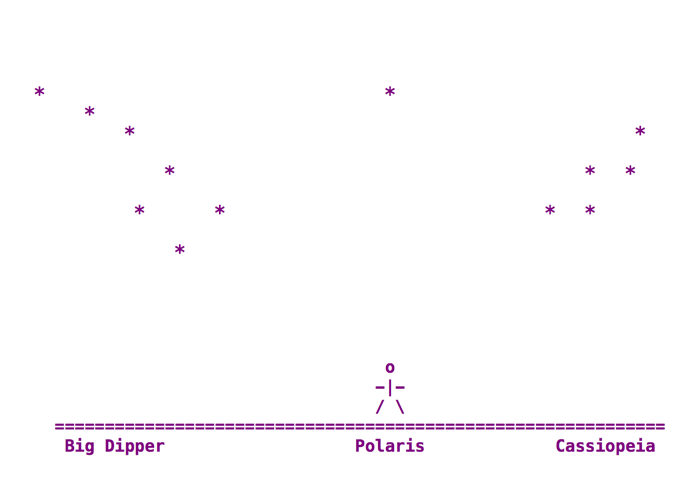
The above diagram shows some of the important stars in the night sky as seen in Canada and all countries of the northern hemisphere. The seven stars on the left are the Big Dipper (a cooking pot with a long handle) that is part of a much larger Ursa Major constellation. The five stars on the right form a large "W" which is the Cassiopeia constellation. The star in the center directly over the stickman is the North Star. According to astronomers the official name of the North Star is Polaris. Polaris is part of the Small Dipper and Ursa Minor constellation which I have not drawn.
If you draw a straight line through the two stars of the Big Dipper that are closest to the stickman in my diagram then the line should point directly at Polaris. The distance from Polaris to the Big Dipper is approximately equal to the distance from Polaris to Cassiopeia. You should therefore be able to imagine drawing a large circle around Polaris that passes through the Big Dipper and Cassiopeia. Cassiopeia will be approximately one third of the distance around the circle from the Big Dipper as measured between the two closest stars.
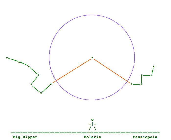
Sorry but the lines in my diagram may not be perfectly straight on your screen. In the night sky a line through the two stars of the Big Dipper should point directly at Polaris with no bends in the line.
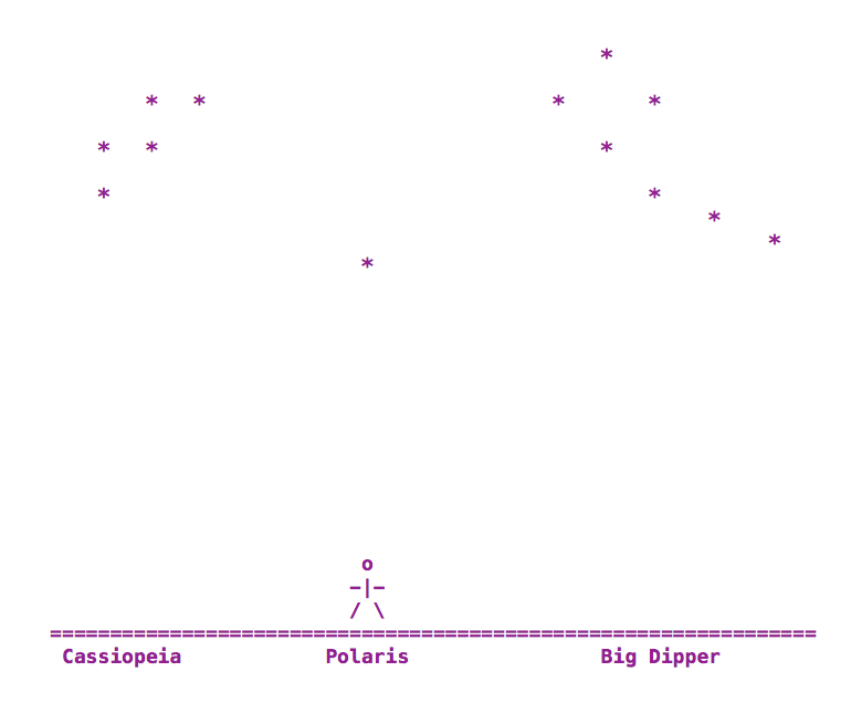
Because we are standing on a spinning earth the Big Dipper and Cassiopeia will appear to slowly orbit around Polaris following the path of the circle you have just imagined. It takes 24 hours for the Big Dipper and Cassiopeia to complete a full circular orbit around Polaris. You need to be able to recognize the Big Dipper and Cassiopeia at all of their different positions and orientations as they orbit Polaris. Down below I have drawn by typing what the stars will look like 12 hours after the first diagram up above.
When living in a remote northern community with very long winter nights it becomes an advantage to be able to look up in the sky and estimate what time it is. After spending a few nights frequently comparing the positions of Polaris, the Big Dipper and Cassiopeia with the time on a clock you should soon be able to amaze your friends with your new ability to estimate what time it is by looking at the stars.
The farther north you travel the higher in the sky Polaris becomes until it is eventually directly overhead when you are at the North Pole. That is why Polaris is often called the North Star, because it is directly over the North Pole. In many of the remote Inuit communities of northern Canada the star Polaris appears to be almost directly overhead.
I found it to be fairly easy to find Polaris in the night sky and determine which direction was north when I was standing on level flat pavement in southern Ontario, just north of the city of Toronto, at about 44 degrees north latitude. It was far more difficult to determine which way is north when looking straight up at Polaris while standing on uneven sloped ground in Clyde River, Nunavut, Canada.
Clyde River is an Inuit hamlet on the arctic coast of Baffin Island, across from Greenland, at about 70 degrees north latitude. The community experiences approximately 60 days of continuous darkness every winter without seeing the sun. When the sun finally does rise again in late January it only stays in the sky for a couple of minutes along the southern horizon at twelve noon and then disappears in a sunset. As there are no trees or other objects to block the view the people living in Clyde River spend most of the winter looking at the stars in the night sky.
I have observed that a traditional compass with a magnetic needle that is suppose to point toward the north pole does not work properly in many locations across northern Canada. I have even used a professional quality mapmaker's compass without achieving any better results. Walking a distance of less than 100 meters in an open field with nothing metallic or electrical within sight could often cause the compass needle to change direction by as much as 120 degrees. It is possible that many remote places in northern Canada are just too near the North Magnet Pole for a magnetic compass to work properly. It is also possible that the compass needle is pointing at concentrations of minerals with strong magnetic properties within the bedrock at many locations throughout northern Canada.
When I was teaching in Kugluktuk (Coppermine), Nunavut, Canada and other arctic communities there were no Global Positioning System (GPS) devices available in the communities. I doubt many Inuit hunters can afford to buy a GPS device today and understand how to use it. In my discussions with the young hunters I was teaching in academic classrooms I discovered that they had been taught by the elders to believe the steepest slope of a hill was generally on the south side. That was true for at least some of the hills in and near their community. Many a hunter over the years has probably become lost trying to find their way home by looking at the shape of the hills. Sometimes a hunter would not have been able to see the hills if they were travelling in fog, freezing rain or when it was snowing. With a snowmobile a hunter may travel over 200 kilometers in the frozen wilderness and then try to find his (or her) way back home.
We must find a better way to tell direction in Canada's north. Something that is readily available, quick to use, affordable for everyone, durable in the cold climate and easy to learn. In southern Canada, the United States and other places around the world with similar latitudes we can look for Polaris positioned over the North Pole provided we can see the stars in the night sky. In the southern hemisphere I have read that sailors and other knowledgeable people look for the Southern Cross which is a small group of stars in the sky very near the South Pole.
Disclaimer:
The above diagrams of the stars were drawn from memory by typing on a keyboard. The diagrams may appear slightly different when viewed on different computer screens. The diagrams are not drawn to scale. Any measurements mentioned in the above text are only approximations suitable for introductory field work with a class of high school students. If you want totally accurate diagrams and measurements then I suggest you obtain a sky chart and visit the websites of planetariums and university trained astronomers.